


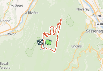
22 La Forestière circuit VTT n22 rouge

nicolas54230
User

Length
26 km

Max alt
1430 m

Uphill gradient
789 m
Km-Effort
36 km

Min alt
1034 m

Downhill gradient
788 m
Boucle
Yes
Creation date :
2025-04-24 17:53:44.465
Updated on :
2025-04-24 17:55:00.651
2h31
Difficulty : Difficult

FREE GPS app for hiking
 SityTrail
IGN / Geographical institutes
SityTrail Plus
The world is yours!
About
Trail Mountain bike of 26 km to be discovered at Auvergne-Rhône-Alpes, Isère, Autrans-Méaudre en Vercors. This trail is proposed by nicolas54230.
Positioning
Country:
France
Region :
Auvergne-Rhône-Alpes
Department/Province :
Isère
Municipality :
Autrans-Méaudre en Vercors
Location:
Autrans
Start:(Dec)
Start:(UTM)
699560 ; 5005637 (31T) N.
Comments